Interesting day at the archives.
I found an old map of the village dated 1826. It was a really interesting find, along with a whole mountain of other unearthed information.
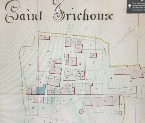
Its really quite an accurate drawing compared to todays laser GPS cadastres – these were the first town maps of 10 million ‘parcels’ (areas of land with defined boundaries) drawn between 1821 and 1850 to define ownership. The real reason was so the State could accurately work out everyone’s land tax!
I feel as if I know the area around the house pretty well now, but I wasn’t expecting the neighbouring land to have been so empty back then!
The house would have been around 50 years old – one of only 40 houses already built in the village.
N°43 is my house
N°44 is Madame Bringuier’s house
N°62 / 63 seemed to be houses as they are shaded pink, but these have now been demolished. Its where the ‘Place de la République’ is now with its fountain
The blue shaded area is a little strange. Its where the old church is now. Maybe someone knows why there’s not a depicting cross shown? There’s no cadastral number either? Hope its not a water feature!

2 responses to “St Frichoux – a map of the village 1826”
Very nice indeed. The omitted cross may have to do with the revolution when all churches were expropriated and became property of the state. No religious symbols permitted. The land register itself is a revolutionary result, this Napoleontic Cadastre having started in 1807.
Yes I’m sure you’re right.
I just read that all actual ‘property’ and items termed ‘biens nationaux’ (whether it was the stone building or what was inside it), were confiscated and later sold by auction to alleviate the National Debt after the Revolution.